MD Legislature Redraws Congressional Map
December 21, 2021
In December, the Maryland Legislature held a special session to pass a new Congressional Map. They succeeded on December 9th, redrawing all of Maryland’s congressional districts for the next ten years. Governor Larry Hogan quickly vetoed the map, but it was overridden by the Democratic legislature later in the afternoon.
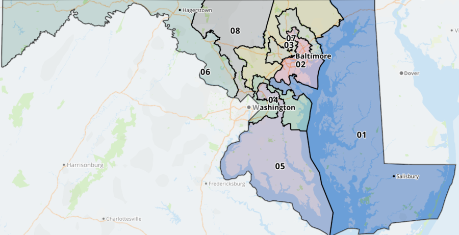
Maryland’s new Congressional map moves many Maryland citizens from their current districts. For instance, all of Crofton will now be represented by Congressman Andy Harris (R) Cockeysville. Harris currently represents the entire Eastern Shore and parts of Baltimore and Harford Counties.
In this new map, Andy Harris’s district was drawn to be extremely competitive, with Democrats being favored to win in all other districts based on past trends. In the 2020 Presidential Election, for instance, Joe Biden won the new 1st by 0.3%, making it a very close district. There could potentially be 8 Democrats and 0 Republicans representing Maryland in Congress.
Do the communities of Odenton and Crofton have the same interests as those living on Kent Island and the rural farming communities of the Southern Eastern Shore? Many do not think so in our school and have varying opinions. I showed people a picture of the map and asked for their reactions.
Freshman Brady Blonder said, “Honestly the new map looks pretty weird, like why is the blue district (The 1st) going across the shore like that?” While Sophomore Spencer McCall thought it looked “just fine.”
Current Governor Larry Hogan attempted to address the inevitable Gerrymander of Maryland earlier in the year. Gov. Hogan created an independent commission that proposed a very fair map in November. But the legislature rejected the commission’s map after just an hour of debate.
The independent commission’s map would’ve given Republicans better representation in the Western part of Maryland by drawing a Republican-leaning district, keeping many once split Counties together. In the proposal, Democrats would be favored to win in six Congressional districts and Republicans two during a normal election year. Princeton Colleges Gerrymandering Project actually gave this map an “A” for being fair and compact.
Many local officials are upset with the new map as well. In an article in the Washington Post, State Senator Edward R. Reilly said “This map takes the Eastern Shore and points it into Anne Arundel County… Sen. Edward R. Reilly (R-Anne Arundel), noted how the new 1st District would jump the Chesapeake Bay. “And it is my opinion that it is for the sole purpose of removing the sole remaining Republican congressman.”
Nancy King, the State Senate Majority Leader, vehemently disagrees, and said in the same Post article that “The congressional map … has cleaner and significantly more compact districts than the current map.” However, some believe this is untrue, and Senate Minority Leader Bryan Simonaire (R) of Anne Arundel County counters this claim angrily.
In the same article, Senator Simonaire said, “When you start with a gerrymandered map as the basis… how are you not going to end up with a gerrymandered map again?” This is true because the old map already splits up many counties based on how they vote, usually in Democrats’ favor.
In conclusion, Democrats still outnumber Republicans in Maryland 2-1, but this doesn’t necessarily mean that Democrats should have all 8 congressional districts. This issue is important and gerrymandering alone could determine the outcome of the 2022 midterms.